| Maker(s): | Pownall, Thomas (bp. 1722-1805); Evans, Lewis (c.1700-1756)
| | Culture: | British
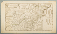
| | Title: | A Map of the Middle British Colonies in North America. First Published by Mr. Lewis Evans, of Philadelphia, in 1755; and since corrected and improved, as also extended with the addition of New England, and bordering Parts of Canada; from actual Surveys now lying at the Board of trade. By T. Pownall MP.
| | Date Made: | 1776
| | Type: | Map
| | Materials: | hand-colored engraving; laid paper; ink; watercolor
| | Place Made: | Great Britain: England: London
| | Measurements: | Sheet: 23 in x 38 in; 58.4 cm x 96.5 cm; Plate: 1 13/16 in x 33 1/4 in; 4.6 cm x 84.5 cm
| | Accession Number: | HD 2018.25
| | Credit Line: | Hall and Kate Peterson Fund for Paintings, Prints, Drawings, and Photographs
| | Museum Collection: | Historic Deerfield
|
|
|
Description:
Map depicts the eastern colonies from Nova Scotia on the east to the lower Ohio Valley, and from Montreal south to Virginia. It employs the original plate of Lewis Evans' Map of the Middle British Colonies in North America with revisions, and adds new iformation on a new plate that extends the map to the east. This includes lists of townships in Rhode Island, New Hampshire Massachusetts (including Maine). Original plate engraved by James Turner of Philadelphia. Prior to acquisition, of this copy, a paper backing was attached to the map. Inscription on verso was transcribed onto paper backing as follows: "Note in pencil upper left corner / Presented by Franklin Hamilton (?) Bache of Philadelphia. Found among the papers of Dr. B. Franklin" [Original inscription is visible when back-lit.] References: B. McCorkle, New England in Early Printed Maps, 776.24; Sellers & Van Ee, Maps and Charts of North America and the West Indies,710; H. Stevens, Lewis Evans, His Map of the Middle British Colonies in America.
Link to share this object record:
https://museums.fivecolleges.edu/detail.php?t=objects&type=ext&id_number=HD+2018.25 |