| Maker(s): | Conder, Thomas
| | Culture: | English (1750?-1831)
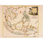
| | Title: | map: A Map of the East India Islands
| | Date Made: | 1778
| | Type: | Map
| | Materials: | paper, ink, watercolors, wood, glass
| | Place Made: | United Kingdom; England; London
| | Measurements: | framed: 22 x 23 x 3/4 in.; 55.88 x 58.42 x 1.905 cm
| | Accession Number: | HD 2004.27
| | Credit Line: | Hall and Kate Peterson Fund for Paintings, Prints, Drawings, and Photographs
| | Museum Collection: | Historic Deerfield
|
|
|
Description:
Framed hand-colored (not contemporary) map engraved by Thomas Conder, with a cartouche in the right: "A Map of the East India Islands, agreeable to the most approved Maps and Charts, By Thos. Conder. 1778.", set in a shield with a classical urn and column, two-story house on stilts, and three snakes. Written across the center top is: "Engraved for Moore's New and Compleat Collection of Voyages and Travels."; on the upper right corner: "Longit. East from Ferro."; and on the lower right corner: "Longit. East from London." The map includes southern China, Cochin China, Formosa, Laos, Siam, Pegu, Cambodia, Malacca, Sumatra, Isles of Sunda, Java, Borneo, Celebes, New Guinea, etc. The Sunda Straits dividing Sumatra from Java were considered to be one of the most dangerous parts of a voyage to Canton; pirates prowled the area in their proas, swift-sailing outrigger sailing canoes made from logs, palm leaf matting and bamboo. Herman Melville in "Moby Dick" describes: "Time out of mind the piratical proas of the Malays, lurking among the low shaded coves and inlets of Sumatra, have sallied upon the vessels sailing through the straits, fiercely demanding tribute at the point of their spears. Though by the repeated bloody chastisements they have received at the hands of European cruisers, the audacity of these corsairs has of late been somewhat repressed; yet, even at the present day, we occasionally hear of English and American vessels, which, in those waters, have been remorsely boarded and pillaged." Samuel Eliot Morrison in the Maritine History of Massachusetts, 1783-1860, describes: "Thank God we are clear of the Sunda Strait...T'is surprising to see the joy depicted on everyone's countenance at getting clear of these horrid straits. Many sailors who had never been off duty was now obliged to take to their bed. Many a time they had to support themselves on a gun while doing duty. Still would not give out until we got clear. Such men as these deserve my best regard." The plate size is 13 3/8" x 15 1/4".
Link to share this object record:
https://museums.fivecolleges.edu/detail.php?t=objects&type=ext&id_number=HD+2004.27 |