| Maker(s): | Sanson, Nicolas d'Abbeville (1600-1667)
| | Culture: | French
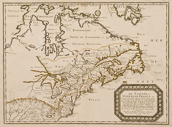
| | Title: | map: Le Canada ou Nouvelle France, &c.
| | Date Made: | 1656
| | Type: | Map
| | Materials: | paper, ink, watercolor
| | Place Made: | France; Paris
| | Measurements: | overall: 17 7/8 in x 24 in; 45.4 cm x 61 cm; Plate: 16 1/4 in x 21 3/4 in; 41.3 cm x 55.2 cm
| | Accession Number: | HD 2010.9.1
| | Credit Line: | Hall and Kate Peterson Fund for Paintings, Prints, Drawings and Photographs
| | Museum Collection: | Historic Deerfield
|
|
|
Description:
Map of eastern North America depicting the landmass from Newfoundland to the area west of Lake Superior, and from Davis Straits (northeast of Hudson Bay) south to the present-day South Carolina. Southern New England is divided between "Nouveau Pays Bas" and "Terre Nouveau," both indicating New Netherland. Cape Cod is labeled "N Hollande." The Connecticut River doesn't extend much farther north than present-day Massachusetts. The Sekokis ("Secoquieis"), a small Native group that resided in the vicinity of Northfield, MA, are noted by name. Map engraved by Jean Somer; published by Pierre Mariette. Sanson based the map primarily on Jesuit sources, retaining Champlain's basic cartographic model for the northern parts of Canada. He added some nomenclature of James, Foxe, and Button and retained the earlier concept of Button's Northwest Passage, in the southwest corner of the bay. The most important aspect of the map is the first appearance of "L. Erie, ou du Chat" as a recognizable lake. This delineation influenced the cartography of the region for over 100 years and was not superceded until De l'Isle's "Carte du Canada" in 1703. The entire Great Lakes basin and the St. Lawrence River is shown in great detail. Lake Superior and Michigan (Lac du Puans) are left open-end to the west. Other geographical improvements introduced with this map include a more detailed Hudson Bay, introduction of Long Island, and the correct position of New Amsterdam. The Delaware River's course is greatly improved and the Swedish Colony noted (although by then defeated). New Netherlands is shown extending to Cape Cod. The original outline coloring reflects the French version of territorial boundaries. Published by Pierre Mariette.
Link to share this object record:
https://museums.fivecolleges.edu/detail.php?t=objects&type=ext&id_number=HD+2010.9.1 |