| Maker(s): | Carleton, Osgood; Callender, Joseph; Hill, Samuel; Loring, B & J | | Culture: | American
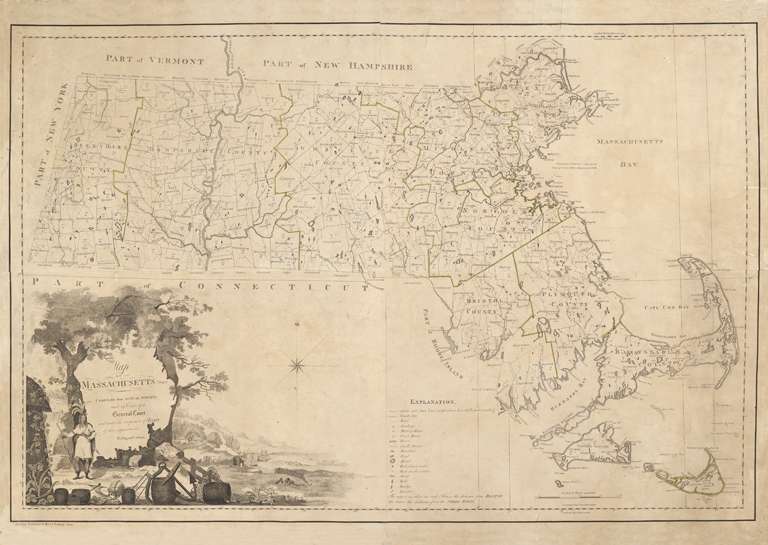
| | Title: | Map of Massachusetts proper compiled from actual surveys made by order of the General Court, and under the inspection of agents of their appointment.
| | Date Made: | 1802
| | Type: | Map
| | Materials: | hand-colored engraving on laid paper; mounted on linen
| | Place Made: | United States: Massachusetts: Suffolk county: Boston
| | Measurements: | Sheet: 32 in x 46 1/8 in; 81.3 cm x 117.2 cm
| | Accession Number: | HD 2018.29
| | Credit Line: | Hall and Kate Peterson Fund for Paintings, Prints, Drawings, and Photographs
| | Museum Collection: | Historic Deerfield
|
|
|
Description:
This is the second edition of the first official map of Massachusetts, based on surveys requisitioned by the General Court in 1794. Osgood Carleton (1741-1816) compiled both versions of the map; the first, dated 1798, was rejected by the Court due to errors and poor quality of engraving by Carleton's publishing partner, John Norman. A revised map by Carleton, engraved by Joseph Callendar (1751-1821) and Samuel Hill (c.1765-1809), was first printed in 1801. This copy, the second state of the second edition is identical to the 1801 printing except with the addition of the B. & J. Loring imprint. The map features a large, handsome cartouche drawn by G[eorge] Graham that features a Native American and images of commerce, geography, and navigation.
Tags:
Native American Link to share this object record:
https://museums.fivecolleges.edu/detail.php?t=objects&type=ext&id_number=HD+2018.29 |