| Maker(s): | Senex, John
| | Culture: | English (1678-1740)
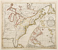
| | Title: | map: A New Map of the English Empire in America, viz Virginia, Maryland, Carolina, Pennsylvania, New York, New Jarsey, New England, Newfoundland, New France &c.
| | Date Made: | 1719
| | Type: | Map
| | Materials: | paper; ink; watercolor
| | Place Made: | United Kingdom; England; Greater London: London
| | Accession Number: | HD 2013.34
| | Credit Line: | Museum Collections Fund
| | Museum Collection: | Historic Deerfield
|
|
|
Description:
Map of North America depicting the Atlantic coast from Florida to Newfoundland, west to the Mississippi. Includes an inset map in the lower right titled A General Map of the Coasts and Isles of Europe, Africa and America, depicting the Atlantic Ocean from Europe and Africa to the Americas, above the Equator. Above this is an inset plan titled The Harbour of Boston or Massachusetts Bay. Engraved by John Harris. The map is a revised version of a map of the same title by Robert Morden (London, 1695).
Link to share this object record:
https://museums.fivecolleges.edu/detail.php?t=objects&type=ext&id_number=HD+2013.34 |
|
Research on objects in the collections, including provenance, is ongoing and may be incomplete. If you have additional information
or would like to learn more about a particular object, please email fc-museums-web@fivecolleges.edu.
|