| Maker(s): | Senex, John; Price, Charles; Maxwell, John
| | Culture: | British
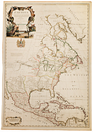
| | Title: | Map: North America corrected from the observations communicated to the Royal Society at London, and the Royal Academy at Paris
| | Date Made: | 1710
| | Type: | Map
| | Materials: | hand-colored engraving; laid paper; ink; watercolor
| | Place Made: | Great Britain: England; Great Britain: Greater London, London
| | Measurements: | Sheet: 38 1/8 in x 27 1/8 in; 96.8 cm x 68.9 cm; Plate: 37 1/8 in x 26 1/8 in; 94.3 cm x 66.4 cm
| | Accession Number: | HD 2018.26
| | Credit Line: | Hall and Kate Peterson Fund for Paintings, Prints, Drawings, and Photographs
| | Museum Collection: | Historic Deerfield
|
|
|
Description:
This large map depicts the continent from northern Canada to the coast of Columbia and Venezuela, and westward to Baja California. English engraver and map publisher, John Senex (1678-1740), drew on a variety of sources for this map, including a report by Deerfield native Joseph Kellogg (1691-1756) referenced in the map's title. A captive of the 1704 raid on Deerfield, Kellogg stayed in Canada for ten years, became an interpreter for the French, and travelled on western explorations with them. His report provided information on the Great Lakes, then little known to the English. Other sources include Guillaume Delisle's 1703 maps of Canada, Florida, and Mexico.
Link to share this object record:
https://museums.fivecolleges.edu/detail.php?t=objects&type=ext&id_number=HD+2018.26 |